Tag Archives: Fairmount Villa

Fairmount Villa

by Janice Hamilton and Lucy Anglin (second cousins)

Fairmount Villa was the home of our great-great-grandparents, Montreal notary and landowner Stanley Clark Bagg (1820-1873,) or SCB, and his wife, Catharine Mitcheson Bagg (1822-1914). SCB died of typhoid at age 53, but Catharine continued to live in the house with her son and four daughters until they all married, and she remained there until her death at age 92. 

1913 – CMB, Mary Heloise Lindsay, Ada Griffiths & son Julius

In his family history notes, Stanley Bagg Lindsay, SCB’s and Catharine’s grandson and Lucy’s great uncle, reminisced about playing in Granny’s garden. “There were apple trees, especially one which was easy to climb and play house in. There was an iron bench under it, painted blue green…. There was a chestnut tree which we loved, the summer house, the white statutes of Adam and Eve with no arms, … the bleeding hearts, snowballs and lilacs … Nora the housemaid and Jessie the cook, who made good ladies fingers and sponge cakes and who we could always see through large sunken window which gave light to the kitchen.” 

“There were the stables, the horses, the rockaway and the brougham (buggy) and Willis the coachman with white mutton chop whiskers whom we liked and who afterwards drove a wagon for Joyce the confectioner. We were very fond of Odell Comtois who did sewing…. She was practically one of the family.” 

Stanley Lindsay continued in his notes about visiting Granny Bagg: “We fondly remember her sitting at the front drawing-room window at Fairmount, her white lace cap perched on her head, watching the world go by.”  He concluded, “The garden had become quite shabby.” “It seemed a large garden to us. It went as far as our house which was at the corner of Milton Street. The west side adjoined the Wilson-Smith property. Long before our house was built, a large house called Tara Hall stood just north of Milton Street. Mother [Mary Heloise (Bagg) Lindsay] remembers it burning down one night when she was a child. Where the house used to stand is a street called Tara Hall.”10

The property records date back 300 years.  In 1701, the land where the house later stood belonged to a religious community called the Charon Brothers.  Later, in the mid-1700s, the Grey Nuns (Soeurs grises) inherited it.  Around 1780, the sisters sold three lots at the crest of the hill, which would later become Sherbrooke Street. These lots were subdivided and resold multiple times. In 1837, merchant Stanley Bagg (the father of SCB) purchased lot number 58A at a sheriff’s auction.  Sheriffs often seized properties when owners couldn’t pay their debts and auctioned them off at a discount for new buyers.  
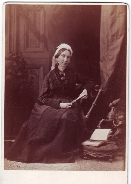
Catharine Mitcheson Bagg, William Notman, year unknown, private collection.

When SCB and Catharine were married in 1844,5 Stanley sold the property to his only son. It was at the north-west corner of Sherbrooke Street, running 2½ arpents north along Upper Saint–Urbain Street to the property line of Durham House, where SCB was born and grew up.

The notarial act in which the transfer was recorded described the Fairmount property as having “a two-storey stone house and other buildings thereon erected.”6 So the house was probably still under construction in 1844, and SCB and Catherine lived at Durham House with Stanley for a few years until Fairmont Villa was built. Their first child, who died at age two, was born at Durham House, but the others were all born at Fairmount Villa.

Some years later, an addition was added to the west side of Fairmount Villa. It included SCB’s office and a second front door so that farmers coming to pay the rent they owed to SCB did not have to walk through the house to get to the office.7

In his letter to The Montreal Gazette, Sydenham Bagg Lindsay, Stanley’s brother and Lucy’s grandfather, also noted there was a family chapel at Fairmount Villa, called the Oratory of the Holy Cross. “The stained glass window in this chapel depicted Christ as the Saviour of the World; it was given in recent years to the Anglican Church at Lake Echo….”9

Sydenham explained that the name Fairmount Villa was reminiscent of Philadelphia. Catharine Mitcheson grew up in a rural area just north of Philadelphia called Spring Garden.8 (It is part of the city today.) Philadelphia’s famous Fairmount Park was located nearby. The naming of Fairmount Villa after a place associated with Catherine’s early life was something of a family tradition: the house in which Catharine grew up was called Menteith House, after Catharine’s mother’s birthplace, Menteith, Perthshire, Scotland.

This painting of Monteith House, the family home in Spring Garden, was painted by Catharine Mitcheson. Bagg family collection. 

After Catharine’s death in 1914, the house was sold to the Asch advertising company, which eventually became known as Claude Neon. The City of Montreal expropriated the property in 1948 in order to widen Saint-Urbain Street. 

In September 1948, The Montreal Gazette published a letter announcing the demolition of Fairmount Villa, a house that had stood proudly on Sherbrooke Street near Saint Urbain for over a century. 

The house has been gone for over 75 years, yet it’s not entirely forgotten.  After all, Fairmount Avenue in Montreal’s Mile End neighbourhood was named in its honour in 1892!

Photo credits:

Studio of Inglis, “Residence of Stanley Clark Bagg,” 1875, Bibliothèque et Archives nationales du Québec http://numerique.banq.qc.ca/patrimoine/details/52327/1956159 (accessed Dec 6 2019)

Chas. E. Goad, Atlas of the City of Montreal from special survey and official plans, showing all buildings and names of owners, 1881, plate VII; detail of digital image, digital image 10, Bibliothèque et Archives nationales du Québec,http://numerique.banq.qc.ca/patrimoine/details/52327/2246915?docref=MtCYGy_XY512L82RM1ifMA (accessed Dec. 16, 2019)

Sources:

1. Sydenham Bagg Lindsay, “Montreal Landmark Destroyed,” Letters From Our Readers, The Montreal Gazette, Sept 1, 1948, p. 6. 

2. Justin Bur, Yves Desjardins, Jean-Claude Robert, Bernard Vallée et Joshua Wolfe, Dictionnaire Historique du Plateau Mont-Royal, Montréal: Les Éditions Écosociété, 2017, p. 149.

3. Justin Bur, email to the author, Dec. 9, 2019. 

4. J.A. Labadie, Inventory of Stanley Clark Bagg’s Estate, notarial act #16732, 7 June 1875, item no. 236;  Bibliothèque et Archives nationales du Québec. 

Stanley Bagg only bought about half of lot 58A, but he also purchased two neighbouring lots, greatly expanding the grounds. Later, SCB sold off a part of the property that he didn’t want, creating a long narrow piece of land along Upper Saint Urbain Street that he divided into lots. 

5. The wedding took place on Sept. 9, 1844 at Grace Church, Philadelphia. 

Historical Society of Pennsylvania; Philadelphia, Pennsylvania; Historic Pennsylvania Church and Town Records; database and images; Reel: 1078; Ancestry.com (www.ancestry.ca, accessed Dec. 16, 2019,) entry for Catharine Mitcheson; Citation Year 1844, Pennsylvania and New Jersey, Church and Town Records, 1669-2013, citing Historic Pennsylvania Church and Town Records. Philadelphia, Pennsylvania: Historical Society of Pennsylvania. 

6. Henry Griffin, notarial act # 20645 (approximate page number;) June 1, 1844; also mentioned as items 235 and 237 in the inventory of SCB’s estate, prepared by J.A. Labadie, notarial act #16732; Bibliothèque et Archives nationales du Québec.  

7. Stanley Bagg Lindsay, handwritten notes on Stanley Clark Bagg; Lindsay family collection. 

8. 1840 United States Federal Census, database; Ancestry.com (www.ancestry.ca, accessed Dec. 16, 2019), entry for Robert Mitcheson; Citation Year:1840; Census Place: Spring Garden Ward 1, Philadelphia, Pennsylvania; Roll: 487; Page: 259; Family History Library Film: 0020555; citing Sixth Census of the United States, 1840. (NARA microfilm publication M704, 580 rolls). Records of the Bureau of the Census, Record Group 29. National Archives, Washington, D.C.

9. Sydenham Bagg Lindsay, Ibid.

10. Stanley Bagg Lindsay, handwritten notes on Catharine Mitcheson; Lindsay family collection.

A Neighbourhood of Rural Villas

In collaboration with Justin Bur

Montreal in 1832, painting by James Duncan. McCord Stewart Museum.

This view of the city of Montreal from the slope of Mount Royal was painted by artist James Duncan in 1832. In the distance, the city lay on the banks of St. Lawrence River, while in the foreground, the foot of the mountain was rural and traversed by only one road – today’s Saint-Laurent Boulevard.  

This area is now a dense neighbourhood of homes, shops and commercial buildings, but 200 years ago, it was described as a neighbourhood of rural villas. Several of those buildings belonged to my ancestors, including butcher John Clark (1767-1827) and merchant Stanley Bagg (1788-1853). These homes were all torn down years ago, but fortunately, artists and photographers captured them before they disappeared. This article tells their stories.  

Saint-Laurent Boulevard began as a country road passing through a landscape with a mix of rural functions. In the 1700s, a large tannery was located nearby, to the east along Mount Royal Avenue. Later, numerous quarries were excavated to provide the grey limestone used for much of Montreal’s Victorian architecture – churches, civic buildings, places of business and attractive houses. The Beaubien family acquired a large tract of land along the east side of the road in 1842, as well as property in what later became the municipality of Outremont. A railway line was built across the Bagg and Beaubien land in 1876, along which an industrial corridor emerged in the early 1900s.

During the lifetimes of the Clarks and Baggs, their property, on the west side of Saint-Laurent, was farmland. The soil was mostly sandy and rocky. Hay to feed cattle and horses was the main crop, but vegetables and fruit trees could be grown in fertile areas. Back from the road, rising up toward the side of the mountain, there were a handful of rural villas belonging to the Baggs and a few neighbours, including the Perrault-Nowlan and the Hall families.

Butcher John Clark, my four-times great-grandfather, was the first member of my family to live in this area. He brought his wife and young daughter to Montreal around 1797 from County Durham, in northern England, and began investing in land. In 1804, Clark purchased a farm on the west side of Saint-Laurent, and over the next few years, he added adjacent parcels of land. He called the property Mile End Farm, probably inspired by Mile End in London, England.1 His choice of name is still familiar today, as this neighbourhood is known as Mile End. In 1810, he leased the farm to American-born Phineas Bagg (c. 1751-1823) and his son Stanley,2 and they ran an establishment called the Mile End Tavern there until 1818.

Montreal Hunt Club at Mile End Road, Montreal, QC, 1859. photograph by J. Henry, MP-1978.29.8, McCord Stewart Museum. The corner of the building on the right is likely the Mile End Tavern.

After Phineas retired and Stanley moved on to other business interests, various tenants operated the Mile End Tavern. It was demolished in 1902 when the local municipality expropriated the land to widen Saint-Laurent Boulevard. New owners purchased the lot in 1905, and the following year a department store opened on the corner of Saint-Laurent and Mount Royal Avenue, where the tavern had stood for so long.3 The department store was converted into a commercial building during the Great Depression. Today, a Couche Tard convenience store and a Tim Horton’s coffee shop are on its ground floor.

By 1891, both Stanley Bagg and his son Stanley Clark Bagg had died and most of the Mile End Farm property was sold by the late Stanley Clark Bagg’s five adult children to developers McCuaig and Mainwaring.4 An economic depression and lack of basic services such as sewers and tramways delayed development for a few years. Meanwhile, the most valuable lots – the ones that faced Saint-Laurent Boulevard – were divided into five equal shares and allocated at random to the five Bagg siblings.5

Map of Mile End Farm and the locations of Mile End Tavern, John Clark’s Mile End Lodge, Stanley Bagg’s Durham House and Stanley Clark Bagg’s Fairmount Villa, prepared by Justin Bur, 2024.

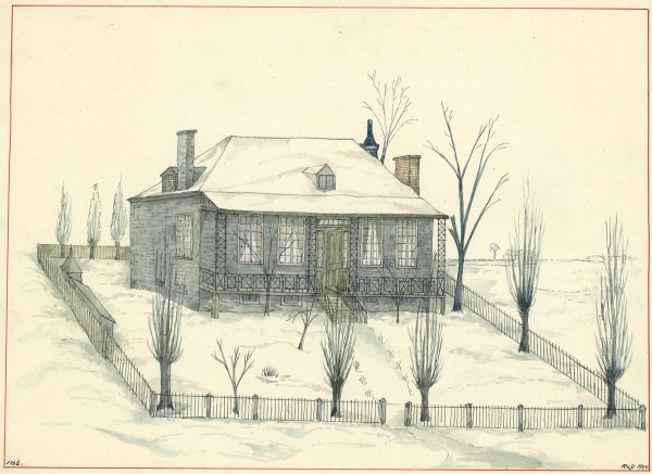
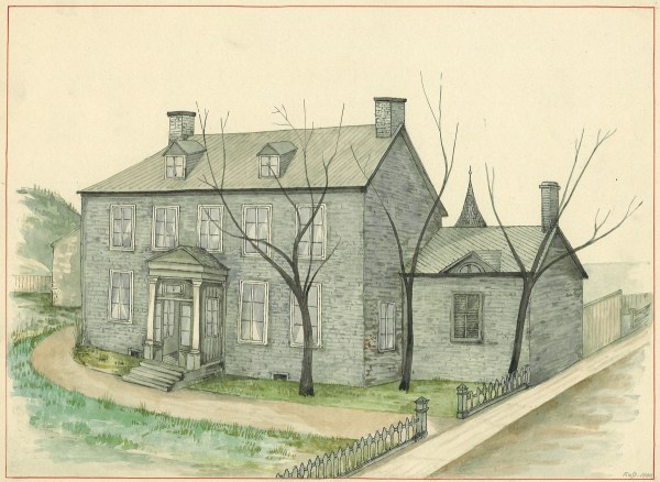
John Clark’s house was not as well known as the nearby tavern. In 1815, Clark sublet a 16-acre square of land back from the Baggs, a “piece of ground on which is erected a new house of butchery called by the said John Clark, Mile End Lodge”6 – in reality, a two-storey stone house for his family. Facing south, toward the city and the river, it was located between the current Bagg and Duluth Streets, just above what was then the Montreal city limit.

After Clark’s death in 1827, his widow, Mary Mitcheson Clark, moved to a smaller house at the current northwest corner of Bagg and Clark Streets. An inscription noting that this was once the location of the Mitcheson Cottage can still be seen on the foundation of the house that stands there today,

Mrs. Mitcheson’s Cottage, watercolour painting by John Hugh Ross, Stewart Museum collection, McCord Stewart Museum, Montreal.

As for Mile End Lodge, although it remained in the hands of Clark’s descendants, no family members ever lived there again. Various tenants rented it over the years. The land around it was subdivided, with a chunk sold in 1873 and the rest in 1893, but the house itself was not sold until 1914. The badly deteriorated building was demolished soon after that, and there is now a large commercial building in that location.7

Mile End Lodge, watercolour painting by John Hugh Ross. Stewart Museum collection, McCord Stewart Museum, Montreal.

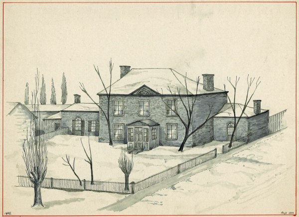
Durham House, the home of my three-times great-grandparents Stanley Bagg and Mary Ann Clark, was located south of the tavern and Mile End Lodge. John Clark purchased the property in December, 1814 and gave it to his daughter as a wedding present in 1819. Durham House was on Saint-Laurent Boulevard, at the current southwest corner of Prince Arthur. Early references describe its address as Côte à Baron.

Durham House, watercolour painting by John Hugh Ross, Stewart Museum collection, McCord Stewart Museum, Montreal.

This two-storey stone building also faced south. There was a covered well on the property, a barn and several other outbuildings. The original Durham House property measured 6 ¾ x 4 arpents, so it was a large piece of land, including property between Prince Arthur and Guilbault Streets, known as the Upper Garden.

After Stanley Bagg’s death in 1853, Durham House was briefly used as a school, then it housed a fruit store for a number of years. Meanwhile, the large property that surrounded it was one of the first to be subdivided for building lots. Stanley Clark Bagg subdivided it in 1846, and the Upper Garden was subdivided by his heirs in 1889. The house was demolished in 1928 to allow for the expansion of the modern TD Bank branch which sits on the spot today.

Stanley Bagg also purchased land near the corner of Sherbrooke Street and St. Urbain at a sheriff’s sale in 1837, and sold it to his son in 1844. Stanley Clark Bagg and his wife, Catharine Mitcheson Bagg (1822–1914), built a large house they called Fairmount Villa on that lot and raised their five children there. The house included a small chapel, while the irregularly shaped property, which extended to the boundary of the Durham House land, had a garden with lilac trees, statues and flower beds. The house was likely named after Fairmount Park in Philadelphia, where Catharine grew up.

Fairmount Villa. photograph, Bagg family collection.

Stanley Clark Bagg died in 1873, but Catharine remained at Fairmount Villa for the rest of her life. The house was sold in 1915, and it was demolished in 1949 when Saint-Urbain Street was widened.

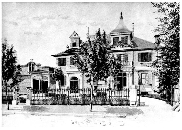
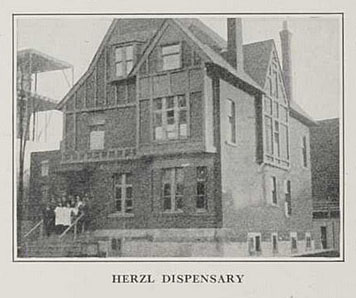
The Fairmount property (lot 100 of the cadastre of St. Lawrence Ward) was subdivided in 1872, then redivided in 1922. In 1884, Stanley Clark Bagg’s son, Robert Stanley Bagg (1848-1912), built a house on one of the subdivided lots, at 436 (later 3470) Saint-Urbain. He and his young family moved to a bigger house in a more exclusive neighbourhood on Sherbrooke Street West a few years later, and his sister Mary Heloise Lindsay and her family lived in the house on Saint-Urbain from 1890 until 1906. The house changed street numbers several times, then changed vocations: it became part of the Herzl Jewish Hospital, was subdivided into apartments, and was finally demolished in the early 1960s.

This house on St. Urbain Street was designed for Robert Stanley Bagg by architect William McLea Walbank. When this photo was taken the building was a medical clinic known as the Herzl Dispensary.

Today, two large buildings that once housed Montreal’s school of fine arts are located on the former Fairmount property. The smaller one, of yellow brick, at 3450 Saint-Urbain, was designed by celebrated architects Omer Marchand and Ernest Cormier in 1923 for the École des beaux arts de Montréal. It will soon be home to Montreal’s new Afro-Canadian Cultural Centre.

The larger building, at 125 Sherbrooke St. W., a heritage building constructed in 1905 as the Commercial and Technical High School, later became the Marie-Claire Daveluy building of the Bibliothèque nationale du Québec (1982–1997). It has housed l’Office québécoise de la langue française since 1999. 

Notes

Built by the Sulpician priests in 1717, Saint-Laurent Boulevard was initially known as a grand chemin du Roy – Great King’s Highway. Over the years it has been known by many names, both English and French, including Chemin Saint-Laurent, St. Lawrence Street and “the Main”. Since 1905, it has been designated Boulevard Saint-Laurent.

The name Côte à Baron, or Coteau Baron, cannot be found on today’s city maps, but in the late 19th century, this was the name of a sloping stretch of Saint-Laurent Boulevard just below Sherbrooke Street and extending a short distance north of there. Côte à Baron was described as a neighbourhood of rural villas. The first-ever Lovell’s city directory for Montreal, published in 1842, listed Stanley Bagg’s home at Côte à Barron.  (https://numerique.banq.qc.ca/patrimoine/details/52327/3652365). Another building with a Côte à Baron address, at the northwest corner of Sherbrooke Street and Saint-Laurent, was an extravagant mansion nicknamed Torrance’s Folly. It was built around 1815 by businessman Thomas Torrance and sold to John Molson in 1832. A gas station is now located at that corner.

An arpent is a French unit of measurement that can refer to either area or length. It is equivalent to an acre of land, or about 58 metres in length. It has been replaced by metric measures since 1970, but can still be found in old property records.

Source of the photo of the Herzl Dispensary: The Jew in Canada: a complete record of Canadian Jewry from the days of the French régime to the present time, ed. Arthur Daniel Hart, 1926 (on BAnQ numérique).

This article is also posted on my personal family history blog, Writing Up the Ancestors. It was updated on Sept. 16, 2025 to add the photo of the Herzl Dispensary.

See also:

Janice Hamilton, “The Mile End Tavern”, Writing Up the Ancestors, October 21, 2013   https://www.writinguptheancestors.ca/2013/10/the-mile-end-tavern.html

Janice Hamilton, “John Clark, 19th Century Real Estate Visionary”, Genealogy Ensemble, May 22, 2019, https://genealogyensemble.com/2019/05/22/john-clark-19th-century-real-estate-visionary/

Janice Hamilton, “The Life and Times of Stanley Bagg, 1788-1853”, Writing Up the Ancestors, October 5, 2016, https://www.writinguptheancestors.ca/2016/10/the-life-and-times-of-stanley-bagg-1788.html

Janice Hamilton, “A Home Well Lived In”, Writing Up the Ancestors, January 21, 2014, https://www.writinguptheancestors.ca/2014/01/a-home-well-lived-in.html

Janice Hamilton, “Fairmount Villa”, Writing Up the Ancestors, Dec. 18, 2019, https://www.writinguptheancestors.ca/2019/12/fairmount-villa.html

Janice Hamilton, “Bagg Family Dispute Part 2: Stanley Clark Bagg’s Estate”, Genealogy Ensemble, Feb. 14, 2024, https://genealogyensemble.com/2024/02/14/the-bagg-family-dispute-part-2/

Janice Hamilton, “History of a Downtown Montreal Property”, Writing Up the Ancestors, Dec. 31, 2022, https://www.writinguptheancestors.ca/2022/12/history-of-a-downtown-montreal-property.html

Justin Bur, “À la recherche du cheval perdu de Stanley Bagg, et des origines du Mile End.” A la recherche du savoir: nouveaux échanges sur les collections du Musée McCord; Collecting Knowledge: New Dialogues on McCord Museum Collections. Joanne Burgess, Cynthia Cooper, Celine Widmer, Natasha Zwarich. Montreal: Éditions MultiMondes, 2015.

Mile End Memories, http://memoire.mile-end.qc.ca/en/

sources:

1.  Justin Bur, Yves Desjardins, Jean-Claude Robert, Bernard Vallée, Joshua Wolfe, Dictionnaire historique du Plateau Mont-Royal (Montreal, Éditions Écosociété, 2017), p 256.

2.  J.A. Gray, n.p. no 2874, 1810-10-17

3.  Justin Bur, Yves Desjardins, Jean-Claude Robert, Bernard Vallée, Joshua Wolfe, Dictionnaire historique du Plateau Mont-Royal (Montreal, Éditions Écosociété, 2017), p 258.

4.  William de Montmollin Marler n.p. no 17571, 1891-11-20

5.  John Fair n.p. no 3434, 1892-05-18

6.      Henry Griffin, n.p. no 931, 1815-04-15

7.   Justin Bur, Yves Desjardins, Jean-Claude Robert, Bernard Vallée, Joshua Wolfe, Dictionnaire historique du Plateau Mont-Royal (Montreal, Éditions Écosociété, 2017), p 259.